Widgetized Section
Go to Admin » Appearance » Widgets » and move Gabfire Widget: Social into that MastheadOverlay zone


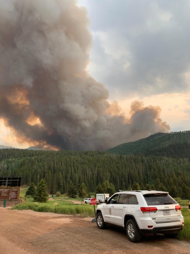
Wildfire near Sylvan Lake exhibiting ‘extreme fire behavior,’ USFS says
Editor’s note: The U.S. Forest Service provided this update Monday morning (June 21) on the 180-acre Sylvan Lake Fire that started Sunday evening (June 20): “Crews worked through much of the night burning fireline along the powerline road. The fire was active all night. We are expecting a mapping flight later this morning and will provide updated acreage and mapping as soon as we have it.” The fire by early Monday afternoon was updated to 400 acres.
Editor’s note 2: Eagle County on Monday morning (June 21) at 9:30 a.m. sent out the following alert in English and Spanish:
PRE-EVACUATION ORDER: As of 0630 AM, the upper Frying Pan from the Dam to Hagerman Pass is under pre-evacuation notice due to the Sylvan Fire. An evacuation center is set up at the Basalt High School (600 Southside Drive) If you choose to evacuate and need resources please go to the Basalt High School. More information is available at www.ecemo.org or follow your local media and social media for updates.
A las 0630 AM, La sartén superior desde la presa hasta el paso de Hagerman está bajo aviso previo a la evacuación debido al incendio de Sylvan. Se ha establecido un centro de evacuación en Basalt High School (600 Southside Drive). Si decide evacuar y necesita recursos, vaya a Basalt High School. Hay más información disponible en www.ecemo.org o siga sus medios locales y redes sociales para obtener actualizaciones.
Eagle County issued this alert a little after 11 a.m. on Monday, June 21: Crews are on scene near Sylvan Lake for a wildfire. There are pre-evacuation and evacuation orders in place in the surrounding areas. Go to www.ecemo.org to view a list and map the specific areas that are affected. Please stay clear of the area.
Here are the USFS and Eagle County reports from Sunday evening, June 20:
At about 6 p.m. on Sunday, the U.S. Forest Service reported a wildfire near Sylvan Lake in western Eagle County had erupted into nearly 100 acres, exhibiting extreme fire behavior. Here’s the brief press release:
Federal and local firefighters are on-scene of the Sylvan Fire burning about ½-mile west of Sylvan Lake State Park in Eagle County. The fire is estimated at 90 acres and growing in lodgepole pine and other timber on the White River National Forest. It is being pushed by high winds and firefighters are reporting extreme fire behavior.
Additional ground crews and aerial resources have been ordered. Campers and others recreating in Sylvan Lake State Park and much of the surrounding lands have been evacuated. Crews are working on structure protection preparation work in Sylvan Lake State Park. There is a major transmission line in the fire area.
The cause is unknown. More information will be shared when it becomes available.
The fire started before 4 p.m. Here’s the original Eagle County alert:
There is a wildfire southwest of Sylvan Lake. There will be emergency responders in the area of Brush Creek Rd and you will see smoke from that direction. Please avoid the area. Click here for more information on this alert.
The Forest Service issued this update at 9 p.m. Sunday:
EAGLE, Colo. — Sixty firefighters, four single-engine air-tankers and a light helicopter worked the 180-acre Sylvan Fire 12 miles south of Eagle, Colo. today.
The fire is burning in timber on the White River National Forest about half a mile from Sylvan Lake State Park. Firefighters reported extreme fire behavior as strong winds pushed the fire to the south and southeast.
The fire was reported about 3:15 p.m. today. The cause is currently unknown and under investigation.
Campers and others recreating in Sylvan Lake State Park and much of the surrounding lands have been evacuated. Much of the area in the vicinity of the fire has been closed, including Sylvan Lake State Park. Firefighters have taken steps to protect structures at the state park. Other infrastructure at risk includes a major powerline in the burn area.
The latest information, including a map of the closure when it is available, is being posted at https://inciweb.nwcg.gov/incident/7562/.
