Widgetized Section
Go to Admin » Appearance » Widgets » and move Gabfire Widget: Social into that MastheadOverlay zone


First major winter storm moving into Colorado just in time for weekend skiers
Forecasters are calling for the first double-digit snowfall total of the 2021-22 ski season Thursday into Friday, with much colder temperatures, windy conditions and the strong possibility of road closures.
“On Wednesday and Thursday morning, the incoming storm will deliver some snow to some areas, but most mountains won’t see much accumulation,” Opensnow.com meteorologist Joel Gratz wrote Wednesday morning. “From Thursday evening through Friday morning, all mountains will see significant snowfall with double-digit totals possible for some spots. Then we’ll track the next chance for a storm around December 15-16.”
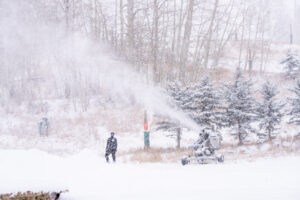
Both Vail and Beaver Creek are open for the season but offering very limited ski terrain due to warm, dry conditions this fall. A few inches fell overnight Monday, but the next storm is expected to be much more significant.
Snowmaking crews have been doing great work so far, allowing the annual Birds of Prey races to be held at Beaver Creek, but they could use a big boost from Mother Nature.
The National Weather Service on Wednesday upgraded a Winter Storm Watch to the following Winter Storm Warning:
ROAN AND TAVAPUTS PLATEAUS-UPPER YAMPA RIVER BASIN- GORE AND ELK MOUNTAINS/CENTRAL MOUNTAIN VALLEYS- NORTHWEST SAN JUAN MOUNTAINS-SOUTHWEST SAN JUAN MOUNTAINS- INCLUDING THE CITIES OF RIO BLANCO, STEAMBOAT SPRINGS, ASPEN, VAIL, SNOWMASS, TELLURIDE, OURAY, LAKE CITY, SILVERTON, RICO, AND HESPERUS 1216 PM MST WED DEC 8 2021
…WINTER STORM WARNING IN EFFECT FROM 6 AM THURSDAY TO 6 PM MST FRIDAY…
* WHAT…HEAVY SNOW EXPECTED. TOTAL SNOW ACCUMULATIONS OF 1 TO 2 FEET. LOCALLY HIGHER AMOUNTS ARE POSSIBLE OVER FAVORED WEST FACING PEAKS. WINDS GUSTING AS HIGH AS 40 MPH.
* WHERE…ROAN AND TAVAPUTS PLATEAUS, UPPER YAMPA RIVER BASIN, GORE AND ELK MOUNTAINS/CENTRAL MOUNTAIN VALLEYS, NORTHWEST SAN JUAN MOUNTAINS AND SOUTHWEST SAN JUAN MOUNTAINS.
* WHEN…FROM 6 AM THURSDAY TO 6 PM MST FRIDAY.
* IMPACTS…TRAVEL COULD BE VERY DIFFICULT TO IMPOSSIBLE. PATCHY BLOWING SNOW COULD SIGNIFICANTLY REDUCE VISIBILITY, ESPECIALLY IN OPEN AREAS. THE COLD WIND CHILLS AS LOW AS 30 BELOW ZERO COULD CAUSE FROSTBITE ON EXPOSED SKIN IN AS LITTLE AS 30 MINUTES. A DETAILED MAP OF THE SNOWFALL CAN BE FOUND AT: WWW.WEATHER.GOV/GJT/WINTER.
PRECAUTIONARY/PREPAREDNESS ACTIONS…
IF YOU MUST TRAVEL, KEEP AN EXTRA FLASHLIGHT, FOOD, AND WATER IN YOUR VEHICLE IN CASE OF AN EMERGENCY. THE LATEST ROAD CONDITIONS FOR THE STATE YOU ARE CALLING FROM CAN BE OBTAINED BY CALLING 5 1 1
