Widgetized Section
Go to Admin » Appearance » Widgets » and move Gabfire Widget: Social into that MastheadOverlay zone


Much-needed snowstorm takes aim at Colorado as wildfires rage
Forecasters were calling for more warmth and wind Saturday — a bad combination for the state’s two massive wildfires — ahead of a major snowstorm Sunday and Monday that could bring more than a foot of snow to the Vail area.
“As we feared, the faster wind speeds on Saturday are leading to additional wildfire growth for the East Troublesome and Cameron Peak fires,” Opensnow.com meteorologist Joel Gratz wrote Saturday morning, referring to the two largest wildfires in state history burning in the north-central region of Colorado.
“Relief arrives on Saturday night as winds slow and on Sunday when snow will arrive,” Gratz added. “A band of intense snow should traverse Colorado on Sunday into Monday with an average of 5-10 inches for most areas and 10-20 inches for a few lucky spots.”
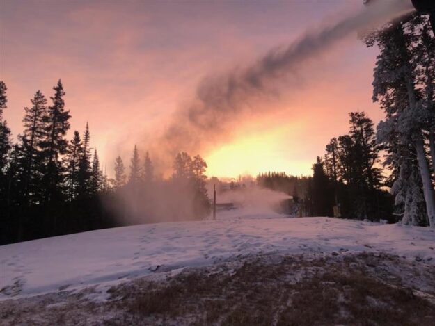
That’s good news for both firefighters and ski areas, where snowmaking has already begun for the uncertain 2020-21 ski season in the midst of the surging global COVID-19 pandemic.
The majority of Eagle County, where Vail and Beaver Creek are located, is in the highest possible state drought category — rated at exceptional. Vail is scheduled to open for the season on Nov. 20, followed by Beaver Creek on Nov. 25. Keystone in neighboring Summit County is set to open on Nov. 6.
Here’s the Winter Storm Watch issued on Friday by the National Weather Service:
Winter Storm Watch
GRAND AND BATTLEMENT MESAS- GORE AND ELK MOUNTAINS/CENTRAL MOUNTAIN VALLEYS- WEST ELK AND SAWATCH
MOUNTAINS- INCLUDING THE CITIES OF ASPEN, VAIL, SNOWMASS, CRESTED BUTTE, TAYLOR PARK, AND MARBLE 136 PM MDT
FRI OCT 23 2020
…WINTER STORM WATCH IN EFFECT FROM SUNDAY MORNING THROUGH MONDAY AFTERNOON…
- WHAT…HEAVY SNOW POSSIBLE. TOTAL SNOW ACCUMULATIONS OF 8 TO 14 INCHES POSSIBLE, WITH LOCALLY HIGHER
AMOUNTS IN THE ELK AND WEST ELK MOUNTAINS. - WHERE…GRAND AND BATTLEMENT MESAS, GORE AND ELK MOUNTAINS/CENTRAL MOUNTAIN VALLEYS AND WEST ELK AND
SAWATCH MOUNTAINS. - WHEN…FROM SUNDAY MORNING THROUGH MONDAY AFTERNOON.
- IMPACTS…TRAVEL COULD BE VERY DIFFICULT, ESPECIALLY OVER MOUNTAIN PASSES. A DETAILED MAP OF THE SNOWFALL
CAN BE FOUND AT: WWW.WEATHER.GOV/GJT/WINTER.
PRECAUTIONARY/PREPAREDNESS ACTIONS…
MONITOR THE LATEST FORECASTS FOR UPDATES ON THIS UPCOMING STORM
