Widgetized Section
Go to Admin » Appearance » Widgets » and move Gabfire Widget: Social into that MastheadOverlay zone
Town of Vail planning ahead on civic area, hiking sustainability

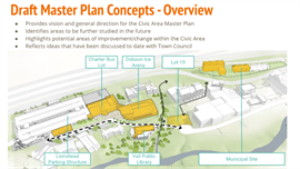
The Town of Vail is planning ahead on a couple of different fronts: the redevelopment of the town’s public amentities in the form of the Draft Civic Area Master Plan and the long-term sustainability of hiking trails in the Vail Valley with the new website HikeVail.net.
First, here’s a press release on the civic area concepts:
The Civic Area Plan is gaining momentum. A final draft plan is scheduled to be released in mid-September, with formal review by the Planning and Environmental Commission and Vail Town Council scheduled to occur in the fall. The civic area plan is a predecessor to future site planning processes, during which decisions specific to each site will be made.
On Aug. 6, Town Council was provided an update on the Draft Civic Area concepts. Please let us know your thoughts by reviewing the concepts and answering two brief questions on engagevail.com.
And here’s a press release on HikeVail.net:
A new hiking website has been launched in partnership with the U.S. Forest Service and the Town of Vail to make it easy to access information about area trails, including tips on how to enjoy the most popular trails as well as alternative hikes to avoid crowding. Creation of HikeVail.net is one of several actions resulting from an ongoing study between the town, White River National Forest and community representatives to address overcrowding issues at the trailheads in East Vail that lead directly into the Eagles Nest Wilderness.
Using updated trail counts, the website lists the best days and times to plan a hike on the five busiest East Vail trails – Booth Lake, Pitkin, Bighorn, Deluge Lake and Gore Creek – as well as times to avoid the East Vail trails. With over 100 miles of hiking trails in and around the Vail area, numerous other hiking options are included on the site as enjoyable alternatives. The site also includes information on stewardship, wilderness, levels of difficulty, dogs, parking, “bus it to hike it” routes and more.
The Vail Welcome Centers and the Vail Chamber & Business Association will prominently feature HikeVail.net in their guest referral communications and will be encouraging lodges and other businesses to do the same.
The new website follows several other actions that have been implemented this summer to improve the overall guest experience at the trailheads and help lay the groundwork for future management considerations. In June, the town introduced a volunteer Trail Host program to help supplement other paid and volunteer programs that are being coordinated by the White River National Forest to provide an increased presence during heavy use periods. In addition, the town has supplied porta-lots at the busiest trailheads and has placed additional emphasis on parking information and public transportation options to minimize neighborhood impacts.
Later this month and again in September, the town, in cooperation with the Forest Service, will be fielding an intercept survey at selected trailheads. Information complied from the hiker surveys will be used to assess crowding, parking and transit options, information sources, trail etiquette and regulations, impact of social media, alternative trail possibilities and future management options.
For more information about HikeVail.net, contact Mia Vlaar, Town of Vail economic development director, at 970-479-2454. To volunteer to be a survey-taker or a Trail Host, contact Amanda Zinn at the Vail Welcome Center at 970-477-3520 or azinn@vailgov.com.
For additional information about trails on the Eagle-Holy Cross Ranger District, you can also contact the Minturn Ranger Station office at 970-827-5715 or visit fs.usda.gov/whiteriver.


