Widgetized Section
Go to Admin » Appearance » Widgets » and move Gabfire Widget: Social into that MastheadOverlay zone


Snowy week at Vail, Beaver Creek, with a lot more in forecast this weekend, next week
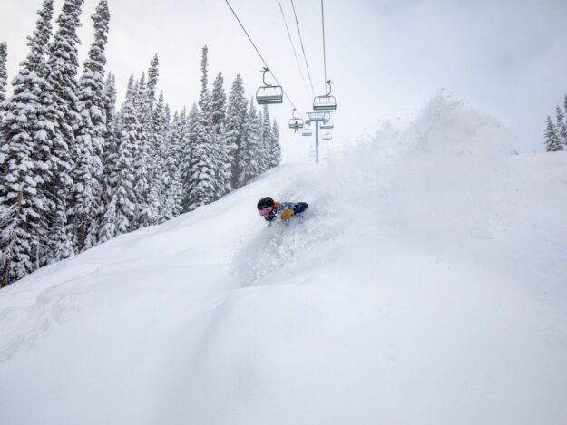
It’s been a snowy week in Vail, with about a foot and a half of new snow bringing seasonal totals to 144 inches and a settled base of 49. Beaver Creek did even better with nearly 2 feet of new snow this week for a seasonal total of 132 inches and a settled base of 40 inches.
Beaver Creek is now 80% open with all 25 lifts running, and Vail is now 87% open, with 30 of 33 lifts running as it works to get its new Sun Down Express (Chair 17) operational.
The really good news as we approach New Year’s Eve is that more snow is in the forecast.
“Friday will bring a mix of light snow, clouds, and maybe a few breaks of sunshine. From Friday night to Saturday night, a high-moisture and warm storm will bring a lot of thick, dense snow to many mountains,” Opensnow.com meteorologist Joel Gratz wrote Friday. “Then from Saturday night through Wednesday, a strong storm will deliver another round of snow to all mountains with fluffier snow quality later during the storm.”
Expect dangerous driving and backcountry skiing conditions as a result. Go to the Colorado Avalanche Information Center, or CAIC, website (currently showing considerable danger in our area) and the Colorado Department of Transportation (CDOT) website for road information.
The National Weather Service on Thursday issued the following Winter Storm Watch for the Colorado mountains, including Vail and the surrounding Gore Range. It calls for another 1 to 2 feet this weekend (between late Friday and Monday afternoon):
GRAND AND BATTLEMENT MESAS-GORE AND ELK MOUNTAINS/CENTRAL MOUNTAIN VALLEYS-WEST ELK AND SAWATCH MOUNTAINS-UNCOMPAHGRE PLATEAU AND DALLAS DIVIDE-NORTHWEST SAN JUAN MOUNTAINS-SOUTHWEST SAN JUAN MOUNTAINS-INCLUDING THE CITIES OF ASPEN, VAIL, SNOWMASS, CRESTED BUTTE, TAYLOR PARK, MARBLE, RIDGWAY, GLADE PARK, TELLURIDE, OURAY, LAKE CITY, SILVERTON, RICO, AND HESPERUS
158 PM MST THU DEC 29 2022
…WINTER STORM WATCH IN EFFECT FROM LATE FRIDAY NIGHT THROUGH MONDAY AFTERNOON…
* WHAT…HEAVY SNOW POSSIBLE. TOTAL SNOW ACCUMULATIONS OF 1 TO 2 FEET WITH LOCALLY HIGHER AMOUNTS POSSIBLE. WINDS COULD GUST AS HIGH AS 40 MPH.
* WHERE…PORTIONS OF SOUTHWEST AND WEST-CENTRAL COLORADO INCLUDING GRAND AND BATTLEMENT MESAS, GORE AND ELK MOUNTAINS, WEST ELK AND SAWATCH MOUNTAINS, UNCOMPAHGRE PLATEAU AND DALLAS DIVIDE, AND THE NORTHWEST AND SOUTHWEST SAN JUAN MOUNTAINS.
* WHEN…FROM LATE FRIDAY NIGHT THROUGH MONDAY AFTERNOON.
* IMPACTS…TRAVEL COULD BE VERY DIFFICULT TO IMPOSSIBLE. PATCHY BLOWING SNOW COULD SIGNIFICANTLY REDUCE VISIBILITY, ESPECIALLY ON RIDGE TOPS. A DETAILED MAP OF THE SNOWFALL CAN BE FOUND AT: WWW.WEATHER.GOV/GJT/WINTER.
* ADDITIONAL DETAILS…EXPECT PERIODIC BREAKS IN SHOWERS AS WELL AS DECREASED INTENSITY AT TIMES.
PRECAUTIONARY/PREPAREDNESS ACTIONS…
MONITOR THE LATEST FORECASTS FOR UPDATES ON THIS SITUATION
