Widgetized Section
Go to Admin » Appearance » Widgets » and move Gabfire Widget: Social into that MastheadOverlay zone


Grizzly Creek Fire grows to more than 25,000 acres and is 0% contained
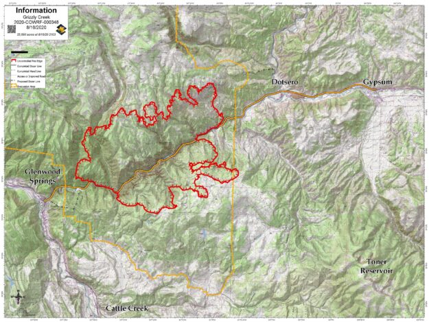
According to the U.S. Forest Service, the Grizzly Creek Fire as of Sunday morning had grown to 25,690 acres with 0% containment by firefighters, although they have managed to keep it from destroying any homes or taking any lives in the area.
The fire started on Aug. 10 and has shut down Interstate 70 in both directions through Glenwood Canyon. Other area roads such as Cottonwood Pass and the Eagle-Thomasville Road have been shut down due to excessive traffic seeking alternative routes. Independence Pass has also been shut down periodically but was open again as of Sunday.
The fire, which has crept east into the western edge of Eagle County, is one of four wildfires burning in drought-stricken Colorado and causing serious air-quality issues.
Colorado Public Radio on Saturday offered this local report: “Pre-evacuation orders remain in place for Dotsero and areas east of the fire. Vail Resorts has agreed to open up 65 rooms in employee housing, if people are evacuated, said Bruce Gillie, who oversees the evacuation center at Battle Mountain High School. The center at the high school will be focused on getting folks water, food, information and shelter, rather than providing beds. Gillie said that because the pre-evacuation order has been in effect for days, a lot of people left to stay elsewhere. At the moment, things remain relatively quiet.”
Gillie, who heads up the local Red Cross, told RealVail.com on Sunday that the center at Battle Mountain in Edwards doesn’t need any more water donations at the present time and that folks wanting to help out should make donations through the national Red Cross or to the local Salvation Army.
Go to the Incident Information System for the very latest on the Grizzly Creek Fire, CoTrip.org for the latest road alerts, and excercise extreme caution with fire in the backcountry. Here’s the USFS press release information as of Sunday morning:
Current Situation: Skies were clear early in the day as the inversion lifted causing higher temperatures and a more active fire. By midafternoon the fire on the north flank made a run from grizzly creek to Coffee Pot Road. The fire did spot across the road, but firefighters were able to catch it as the fuel types transitioned from timber to sage. Spot fires from the previous night grew together and moved towards Bair Ranch. Dozer line around Bair Ranch and structure protection measures, were successful in holding back the fire resulting in no loss of structures. Fire on the southeast edge is holding just shy of Spruce ridge. Heavy smoke in late afternoon was due to the fire pushing between the Deadman canyon and Devil’s Hole Canyon. The fire has moved to the canyon rim and is holding. Activity in the No Name area was quiet as the containment lines held and crews worked to bring in water with hose lays and aerial water drops.
Firefighters will continue implementing structure protection measures around the gondola at Adventure Park and will move north to Transfer Trail with heavy equipment building indirect line. Crews will work to keep fire south of Coffee Pot Road by constructing and reinforcing control lines. Crews will engage the fire where they safely can. Direct attack of the fire has been difficult due to the rugged and steep terrain. Firefighters will hold and improve line construction as fire comes out of deep canyons. At this time the fire is held up on Spruce Ridge, however, there are stringers of heavy timber that are concerning. Contingency line to the east will be implemented by heavy equipment. Today heavy air tankers will be shared with the Pine Gulch Fire. Daily operations video updates will be posted on the Grizzly Creek Fire facebook page. Maps and other information will also be posted on inciweb at https://inciweb.nwcg.gov/incident/6942/.
Evacuations: Please go to Garfield County website at www.Garfield-county.com and Eagle County at www.ecemergency.org, as well as on official FaceBook
Road Closures:
I-70 continues to be closed between Glenwood Springs and Gypsum, with no estimated time for reopening. Forest Service Road 400, Eagle-Thomasville Road, is closed due to excessive traffic and accidents resulting from drivers attempting to use this primarily dirt road as an alternate to the I-70 closure. Cottonwood Pass Road in Garfield and Eagle counties. Coffee Pot Road, Transfer Trail and Clinetop Mesa roads and areas of the Flattops accessed by those roads are also closed, as well as many surrounding White River National Forest and BLM roads. For more information regarding road closures: www.cotrip.org
Area Closures: BLM recreation sites and boat ramps on the southern portion of the Colorado River Road (RD 301) near Dotsero, Colorado. Specifically, Cottonwood Landing boat ramp, Lyons campground and boat ramp, and Dotsero boat ramp.
Fire Restrictions: Stage 2 Fire Restrictions are in place for all jurisdictions. https://colorado.gov/pacific/dfpc/fire-restriction-information
A temporary flight restriction is in place over the fire area. If you fly, we can’t FaceBook
