

For those of you up early this morning (Sunday, Nov. 7), with your clocks still acclimating to Mountain Standard Time (MST), magenta clouds to the east gave early warning of what's to come.
Nearly two weeks have passed since our last measurable precipitation, a whopper of a storm that dropped feet of snow throughout the mountains of Colorado and sent off tornado sirens from Nebraska to Wisconsin.

http://www.vvf.org
Our second round of Indian summer will come to a quick halt as the jet stream has shifted south and will bring with it an active storm period for much of next week (Nov. 8-13). Winds will increase this afternoon in the Vail and Aspen areas as a shortwave system will approach from the northwest with limited moisture and dynamics.
The real action starts Monday night, Nov. 8, with a better shot at snow as a cold front barrels into western Colorado. Overnight lows will drop Monday as the cold front moves through and sets off numerous showers. Winds will increase into the 20-mph range with gusts up to 30 mph as the cold front passes. Overnight lows will be in the low 20s and daytime highs for Tuesday should reach into the 30s.
Snow totals look good so far as dynamics and moisture appear favorable. Timing is everything as ground temps are still be above freezing, so totals will be higher if showers persist overnight.
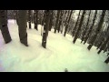
Expect totals for Tuesday morning to range from 3-6 inches on mountain, with 1-3 inches in the valleys.Northwest flow will favor Steamboat and Vail, but the central mountains should benefit from the lift provided by the West Elk and Elk mountains.
The Aspen/Snowmass area should see on-mountain snow totals in the 4-8 inch range by late Tuesday with showers tapering off overnight. Wednesday looks partly cloudy, as one system moves east and another system works its way into the Colorado high country by Thursday.
We will keep close watch this coming week as more resorts drop ropes and start turning on lifts. And as Vail readies for the 2010-11 ski season, many of the top U.S. skiers have been taking advantage of a newly renovated snowmaking system at Golden Peak.
Partaking in pep rallies, autograph sessions, and, of course, training, names like Lindsey Vonn, Bode Miller, and Vail local Sarah Schleper have been spotted around America's No. 2 ski resort.
Finally, rumor has it that Vail's Chair 5 upgrade has been stalled by the recent dumping, making it hard for crews to maneuver in the nearly 3 feet of snow. Luckily, there are still 12 days until opening day at Vail, but Mother Nature may make a hassle of it until then.
For now, let's hope some of that white gold graces the greatest state in the union.
![]() 2 Comments on "Pomp and pep rallies prep Vail's opening day countdown"
2 Comments on "Pomp and pep rallies prep Vail's opening day countdown"
Reid – Nov. 09, 2010, at 7:36 a.m.
--UPDATE FOR TUESDAY NOVEMBER 9 2010--
The slow moving cold front and associated pressure systems stalled over the Great Basin last night, bringing moderate rainfall to areas like Grand Junction south to Delta. This slow moving low should arrive in the mountains by lunchtime and fester over the mountains well into the night time hours. Very light snow falls as of now with one inch of snow on the ground in Edwards (elevation 7400 feet). Thanks for the comment Welch. As of now no one knows what terrain will be open by Nov. 19, however, with 2 feet falling three weeks ago, this system moving slowly and keeping its energy, as well as more systems lined up out west. We should see a big portion of the front side open. Expect chairs 8, 2, 3, 4, and maybe 11 being up and running for opening day. Remember that lift openings also depend on staff issues (lifties, ski patrol, etc..). Hopefully we get a few more dumps so we won't have to share Born Free with each other all day. Keep the comments and the snow coming!! Enjoy!!
Powder Predictor
 Vail Town Council to weigh new plan to redevelop T...
  All about indexes
  Transforming your social security into a winning r...
  Pass sales, real estate transactions, revenues inc...
  Vail Valley native with passion for Biophilic inte...
  Land Trust, ECO Trails, Vail Resorts team up to cl...
  EUROVISION named Host Broadcaster for 2015 World A...
  Vail Resorts brings back Lindsey Vonn's 'School of...
  Hundreds turn out for 2015 World Championships vol...
  Eagle County Senior Health Expo and 9th Annual Hea...
  Final race of Vail Mountain Trail Running Series s...
  Before you write your will ...
  2015 World Ski Championships volunteer recruitment...
  Ascent Sotheby’s International Realty in Vail an...
  CDOT outlines road closures for local stages of US...
  Italian artist creates unique trophies for Vail, B...
  Vail Recreation District once again hosting Jake W...
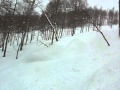
MileHighWelch – Nov. 08, 2010, at 4:56 p.m.
Any ideas on what runs will be open for opening day. Might make the drive up if they will have enough open.